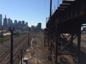
Search

Monday, May 20th, 2013

Replay: Fast and Cheap Ways to Improve Public Transit in Indianapolis Right Now

[ I continue to apologize for the hosting situation. It doesn't look like it will be resolved with this provider. Unfortunately, I'm traveling this week, but hopefully next week will be able to do an emergency cutover to another provider. In the meantime, I strongly encourage you to subscribe, either by email or by RSS.

Given that a major transit expansion in Indianapolis is dead for the moment thanks to the state legislature, I thought I'd dust off this list of no help needed recommendations to start improving transit immediately. It's nearly five years old and so some ideas may be dated, but the thinking of ways to start making change right now for cheap I think is still valid.

By the way, please don't interpret this post as criticizing the mode mix in the Indy Connect plan. That was released after quite a bit of detailed analysis long after I wrote this post - Aaron.> ]

This post originally ran on September 25, 2008.

I’m passionate about public transit. For those of you who know me primarily through my posting about rail transit being a bad idea for Indianapolis, you might not believe me. But I’ve long been a transit rider. In fact, in a previous life I published a transit newsletter for three years. I try to ride transit in every city I visit.

Where I differ from many transit advocates is that I believe that transit should be primarily about rider mobility, and I think we need to take a realistic approach that looks at the facts around development patterns, cost, likely ridership, etc. and not just rely on conventional wisdom from the transit hymnal and build it and they will come logic. As I said in my really, really cheap manifesto, it’s about results, not how much money one can spend.

In light of that, I will lay out a series of ideas about how to improve transit in Indianapolis today, not years from now, that won’t cost much money to implement. Some of them are conceivably even free and can be implemented with existing staff and budgets. I can’t say these are all the right things to do, but I believe all of them are worthy of serious consideration.

  • Run bus service every ten minutes to Fountain Square. To have real bus service, that is to say, where you can just show up and wait for the next bus without consulting a schedule, you need ten minute headways or better all day, maybe 15, but that’s pushing it. Indygo currently operates on 30 to 60 minute headways, which is a non-starter. To really start proving the transit concept locally, Indy needs to start piloting with enhanced service at ten minute headways to see how to make it work or if in fact it can be made to work. The perfect place to start is Fountain Square. This is one of the city’s official cultural districts. Its downtown area is already “transit oriented development” and there is plenty of opportunity for further infill. A segment of the population there is tightly connected to downtown. However, the distance is a bit too far to walk comfortably in bad weather (about 1 ½ miles to the core of the Mile Square). Today, Indygo’s web site tells me there are three routes that go through Fountain Square: the #12-Beechcrest, the #14-Prospect and the #22-Shelby. These three bus routes run on 30 minute headways. Today, they all get to Fountain Square at the exact same time. For example, the #12 arrives at Virginia/South at 7:13am, the #14 gets there at 7:14am, and the #22 also gets there at 7:14am. It looks to me like three buses come in a row, then there isn’t another bus for half an hour. That’s insane. If Indygo simply staggered the routes, a bus could come through Fountain Square every ten minutes – right now, today – without spending an extra dime to add any new service. Now perhaps things are set up this way to facilitate downtown transfers, so perhaps this isn’t a slam dunk decision to make. But I think it goes to show that you could make dramatic transit improvements in an emerging neighborhood that primed to take advantage of it today without spending anything other than the cost of printing new schedules. And for people in Fountain Square, you wouldn’t even need a schedule, which is the whole point.
  • Get a new domain name. indygo.net has to go. A .net domain name is completely bush league. If you can’t spring for a real domain name, no one will take you seriously. If indygo.com is too pricey, at least do indygo.gov or something. Dittos for cirta.us for the Central Indiana Regional Transit Authority.
  • Implement mobile phone bus tracking. Chicago has a system called “Bus Tracker” that uses GPS in buses to feed an online service that tells you how long until the next bus arrives. Right now this is a mobile web app only, but soon they are rolling out a texting solution where you text your stop number to a special number and it texts you back the next buses arriving. This is hugely beneficial to riders on the go. What’s more, even large percentages of poor people have cell phones, so it isn’t just targeting the MacBook crowd. My idea: just contact with the CTA to ride their system. The cost is basically some GPS devices, route mapping, and setup. It’s a win-win. The CTA gets a revenue source to amortize their fixed investment over, and Indygo gets the advantages of economies of scale (i.e., lower unit cost) and speed to market. Imagine what a game changer this could be for Indy. With some buses running only once an hour, people have to get to the stop very early to avoid missing that bus. If you knew exactly when it was arriving, you could cut your wait time with confidence.
  • Leverage texting for emergency messaging. The CTA is also rolling out texting for communicating to riders about service disruptions and other problems. Again, just see if the CTA will let Indygo pay them on an incremental cost basis to ride that infrastructure. (By the way, one source of potential funding for Chicago transit improvements is simply to spin off some of these things into a service bureau / hosted service for other transit providers. Be the “Google Transit” of this stuff before Google is. Eventually they could even float the thing – or just plain sell it to Google for Big Buck$ to pour into capital improvements. Just my free business advice).
  • Start a “Friends of IndyGo” group if one doesn’t exist already. There are all these people who say we need better transit, why not give them the opportunity to see if their deeds match their words? Actually using transit, given the existing service levels, might be a bridge too far. But see if any transit advocates will actually step up to the plate and do something else tangible. A Friends of Indygo group could conceivably take on some of the items I have listed here as volunteer projects, with official sponsorship from the agency.
  • Get integrated with Google Transit – right now. (Potential Friends of Indygo project)
  • Create a better “How to Ride the Bus” guide. I suggested this one in my Pecha Kucha presentation. I’m a hardened transit guy, but even I don’t like to ride buses in cities I haven’t ridden in before because I’m afraid I won’t know how it works and will end up a mark for criminals, or, at a minimum, just plain look like an idiot. What’s needed is a very simple, explicit, step-by-step how to ride guide – both a brochure and a video – that shows exactly how it works, exactly how to put the money in the box, how to signal for a stop, etc. No question is too stupid or obvious to cover. (Potential Friends of Indygo project).
  • Get serious about design. Indygo has a terrible image problem with the public. Transit is stigmatized in Indy in a way that it isn’t in NYC. Great design is something that is, in my opinion, absolutely necessary to create the customer experience and impressions to get people to even consider Indygo. This includes everything from the color scheme, the logos, the web site, signage and shelter design, everything. Consider Indygo’s colors. Who thought that color green looked good on anything? I get the “green” thing, but is that consistent with any other colors used in Indy? (Heck, it isn’t even consistent with the color palette used on the bus shelters downtown). The web site design is mediocre. Even things like good letterhead and a well-chosen font can make a difference. Some of the things are serviceable already (the “I” logo isn’t bad, for example), but could be better. (There’s no reason Indygo couldn’t create a logo that became as iconic as the Boston “T” for example). The large bus shelters are quite nice, but could be tweaked a bit. And the neighborhood shelters are not very nice. Good design frankly doesn’t cost much if anything more than merely serviceable design. It just takes an absolute commitment to creating something that is a) world class and b) both unique to and an expression of Indianapolis. JC Decaux, which usually gives cities bus shelters for free in return for advertising rights (or even pays for the privilege of putting them out there), has an entire subsidiary that designs these, including unique designs for many European cities. Indygo could work with them and insist on a totally world class design that is consistent with Indygo’s revised branding scheme (i.e., good colors). Also, it seems like every other person I stumble across on the internet in Indy these days is a graphic designer or artist. They could do a Friends of Indygo project to do this for free in return for an official credential or something. Similarly, why can’t Indy’s aspiring fashion community design a kick-ass bus driver’s uniform?
  • Own the green agenda, live it internally. Don’t just talk about the sustainability of the bus as a transport mechanism. Look at every aspect of your operation and try to become the signature government agency in the state and a leader nationally in green operational practices. As a small government agency, Indy is positioned to more rapidly change. I sense another Friends of Indygo project coming on. Some local green enthusiasts could review operations, even things like office supplies, and look for areas to improve. Source that locally designed bus drivers uniform I mentioned from a small local producer and use sustainable materials (provided the economics are there, of course).
  • Look for operational synergies with the rest of Marion County government. Is Indygo buying its own fuel, running its on HR policies, etc.? Some things are obviously unique to them, but as the Mayor’s 100 Day Report indicated, there are still duplicative services all over Marion County. Every dime that can be saved through economies of scale or reduction of duplication is a dime that can be invested into the on-field product.
  • Evaluate outsourcing of all functions. Perhaps Indygo could eventually not operate any services directly at all. Privatization isn’t a slam dunk, but it works well for the management of the water utility, so why not here? Again, every dollar saved is a dollar that can go back into core services. London’s famed double-decker buses are contracted out to private companies. If they can do it, so can Indy.
  • Run transit every ten minutes on College Ave. I figured I’d bookend this list with another service improvement. Unlike the Fountain Square idea, this one would require increasing service hours. However, College already has the best service out there, every 15 minutes at rush hour. All you need to do is to increase this to every ten minutes all day (maybe a bit more frequent at the 7am and 5pm hours). Indygo could have already done this with money they got earlier this year. On Feb 7th they issued a press release touting 20,000 new hours of transit service paid for by a $1.6 million state grant. Almost all of this went into point extensions of route at the existing awful service levels. It’s time to stop the “more of the same” approach and start changing the game. If Indy can’t make high quality bus service work on College Ave, it has no business trying to do anything else. Start this ASAP and you can start figuring out what it is going to take from a routing, service, and marketing perspective to get people on the bus. Also, the route should be adjusted to go from downtown to Broad Ripple to Glendale to Keystone Crossing. This links several destination districts with the residential in between. Combine the new service with the new design elements and rider notification systems and you have something to really start showing off.

Waiting around for three years to start a commuter oriented, peak period only rail service with limited stops on one corridor – and that’s in the best case – is a very limited and modest way for Indianapolis to start playing at a different level in the transit game. There is a whole lot that can be done in the mean time to make Indygo better and start delivering benefits to riders, starting right now. It doesn’t take a lot of money, it just takes creative thinking and the help of the community to pitch in and make it happen. Waiting around for some big regional taxing authority to make transit happen is the equivalent of saying transit is somebody else’s problems. If motivated citizens were willing to step up and actually pitch in to make things better, along with targeted improvements paid for by Indygo, the city could start down the transit path faster.

Monday, May 13th, 2013

Milwaukee’s Future as Part of Greater Chicagoland

Last summer I was invited to speak at a conference called “Milwaukee’s Future in the Chicago Megacity” put on by the Marquette University School of Law and the Milwaukee Journal-Sentinel. It was an interesting day of conversation about mega-regional integration between the two metros. In follow-up, Marquette Lawyer magazine asked me to write a piece for them about it. I’m including the full text of that article below. However, the current issue of the magazine has a couple of other major articles on the same topic. These are “Thinking and Acting (and Flourishing?) as a Region” by Alan J. Borsuk and “Rivalry, Resignation, and Regionalization” by John Gurda. I recommend both of these.

In the meantime, my article is below. The first part of it includes material and ideas from my “Don’t Fly Too Close to the Sun” post, but most of the article is original. Enjoy.


Milwaukee and Chicago sit a mere 90 miles apart on I-94. Growth in both metro regions has led to near-continuous development along that corridor, which is being expanded to handle the increasing traffic between the two regions. Amtrak links downtown Milwaukee with downtown Chicago in only 90 minutes, which is shorter than some Chicago commuter rail trips. The two cities share a lakefront heritage and similar industrial history.

With their closeness and parallels, the idea that there’s benefit for the two cities in mutual collaboration is almost obvious. This is particularly the case for Milwaukee as it looks to differentiate itself from peer cities. What does it have that those places don’t? Chicago. This idea was even the subject of an entire conference called “Milwaukee’s Future in the Chicago Megacity,” sponsored by Marquette University Law School and the Milwaukee Journal Sentinel. This essay further explores Milwaukee’s relationship to Chicago.

Is Proximity to Chicago a Positive?

In most discussions of the topic, the increasing integration of Chicago and Milwaukee is assumed to be a positive. But we should ask whether this is so. For other examples of close cities around the country suggest that perhaps a more cautious view should be adopted.

Indianapolis analyst Drew Klacik has suggested a reason to be skeptical about Chicago–Milwaukee. He promotes a model of the Midwest as a solar system with Chicago as the Sun. His idea is that Indianapolis is Earth—it’s the perfect distance from Chicago. A place like Cleveland is like Uranus—it’s too far away and doesn’t get enough heat and light. But in this model Milwaukee is like Mercury—it’s too close to the sun and gets burned up.

Of course, Klacik comes from Indianapolis. But is there something to this notion of being “too close to the sun”? Taking a look at other similarly situated cities suggests some indications that it isn’t always healthy to be located next to a megacity. Providence, R.I., about the same size as Milwaukee, sits just 50 miles from Boston, but shows little signs of life. Neither does New Haven, Conn., 80 miles from New York, or Springfield, Mass., 90 miles from Boston. But these post-industrial cities have struggled for reasons completely independent of megacity proximity.

A more positive example might be Philadelphia, which is 90 miles from New York and seems to be seeing a resurgence due to what we might dub the “Acela effect,” as runaway gentrification chases people from New York. Yet Philadelphia is also a near megacity in its own right. Various post-industrial cities such as Aurora, Elgin, and Joliet have seen new growth as Chicago enveloped them, but they are much closer and much smaller than Milwaukee, and in the same state as Chicago. To the extent that they’ve benefited from being close to Chicago, it’s because Chicago has turned them into suburbs.

The key takeaway might be that Milwaukee’s proximity to Chicago is potentially either a pro or con. It is something that must be studied, and managed as well as possible, to both regions’ benefit. There is no choice to grow together or not grow together. The two regions are growing together as we speak, driven purely by market forces. It is happening on its own. The real question is what, if anything, should Milwaukee’s leaders do about it.

To show the double-edged sword of proximity, consider the case of General Mitchell International Airport. How is service at this airport, and thus for Milwaukee generally, affected by Chicago’s proximity? There are many ways. For example, to the extent that it is more convenient or has lower fares, Mitchell Airport can draw from the Northern Chicagoland region, becoming a de facto third airport for Chicago. This is a positive for Mitchell Airport and Milwaukee. However, to the extent that Chicago has better nonstop flight options, especially internationally, people may choose to drive from the Milwaukee region to O’Hare for a nonstop flight rather than connect. This potentially suppresses Milwaukee air traffic, particularly for international flights. Among metro areas with more than a million people, Milwaukee ranks only 41st in the United States in originating international air passengers per capita, according to Brookings Institution research. This is a negative for Milwaukee. But the flip side is that Milwaukeeans, by driving to O’Hare, have access to many nonstop flights that aren’t options for people in other small cities.

In short, the dynamics are complex and cut both ways. That’s why simple surface thinking will not suffice to manage this problem. It requires a lot of careful analysis and new types of thinking.

Milwaukee Must Go It Alone

Additionally, in its attempts to manage the increasing integration of Chicagoland with Milwaukee, Milwaukee should expect largely to have to go it alone. People from Chicago may come to the occasional conference, but it’s unlikely that Milwaukee will capture much time and attention from Chicago’s leadership. Milwaukee is much smaller. Chicago already has all the scale it needs to compete in its chosen global-city strategy. And Chicago and Illinois both have serious near-term problems that must urgently be addressed. The leadership of the Chicagoland region is mostly Chicago-focused. It can even be difficult to get Chicago and its suburbs to pay attention to each other or get on the same page—how much more so Chicago and Milwaukee. Thus the next key question to ask is this: What can Milwaukee do by itself for itself, without much help from its larger neighbor? What should Milwaukee do to try to shape its future in the Chicago megacity?

A Plan of Attack

Here are some potential ideas to explore.

1. Think “Different.” Milwaukee is similar to Chicago but smaller; hence it can at times view itself as a little brother or “Mini-Me” version of the Windy City. But the approach of being like Chicago is not a positive for integration. Economic gains come from specialization and the division of labor. You can only take advantage of this to the extent that you are different. On a football team, not everybody can be a quarterback or a linebacker. Everybody has to know his role on the team. Milwaukee would be much better served to be a starting wide receiver to Chicago’s quarterback than to settle for second-string QB.

Mike Doyle illustrated the downsides of thinking too much like Chicago in his critique of a local tourism campaign aimed at Chicagoans. One tagline from an outdoor ad was “Beer. Brats. If you had another hand, we’d go on.” But, as Doyle notes, Chicago is arguably already as good a beer and brat town as Milwaukee. Why would people make the trip for something they can already get at home?

Milwaukeeans instantly understand that you go to Chicago to get what you can’t get at home. The city needs to invert that thinking to figure out what it is that you can get only in Milwaukee and not in Chicago. That is where you market your city.

Similarly, in thinking about the best way to relate to Chicago economically, Milwaukee should sort out how the two cities can have complementary specialties.

2. Promote an Expanded Labor Market. Another area of integration is to better market the two cities as an extended labor market. This could take place in various ways. Naturally, making the sale to talent you are trying to attract to Milwaukee that Chicago is a piece of Milwaukee’s value proposition is a given. There may also be people who want to live in Chicago but could potentially be attracted as employees in downtown Milwaukee. This is particularly true if a person needs to be on site only part-time, such as a software developer. Many people reverse commute from the city to the suburbs of Chicago on Metra. There’s no reason they can’t do it on Amtrak as well. Figuring out the addressable market and how to sell it on Milwaukee is the “to do” here.

3. Market Nearshore Outsourcing. The move from Chicago to Milwaukee provides a steep cost gradient while maintaining good physical proximity in a way that provides opportunities for periodic face-to-face interactions. The globalized economy appears to be currently rewarding two models. The first is the “flat world” model of Tom Friedman in which work travels to wherever in the globe it can be produced most cheaply. The second is the “spikey world” model of Richard Florida in which intensive face-to-face collaboration is so valuable that it forces clustering of people and businesses in locations such as downtown Chicago.

Is there an intermediate model where reducing costs is important for certain activities, but face-to-face meetings are still valuable? If so, this is where Milwaukee–Chicago would have a very strong play. Examples may be various types of legal work or business-process outsourcing. For example, Walgreens maintains an operations center in Danville, Illinois, some 135 miles to the south of Chicago along the Indiana border. This is not only lower-cost than Chicago, but it allows executives from Deerfield to make day trips, enabling much better oversight and collaboration than an overseas location would, particularly with the time zone commonality. These types of applications would be something that could be highly beneficial for economic development in Milwaukee.

4. Eschew the Amenity Arms Race. Many cities of the same general size as metro Milwaukee spend much of their time trying to produce amenities that prove they are a “big-league city.” For many of these—stadiums, hotels, convention centers, department stores, high-end restaurants—there is a sort of “nuclear arms race” between cities in which one city after another pumps large subsidies into bolstering these high-end sectors in order to try to distinguish itself from the pack.

For Milwaukee, proximity to Chicago reduces the ability of the city to attract and support these types of amenities. Consider one example: high-end department stores. An analysis by David Holmes discovered that Milwaukee had fewer high-end department stores than regional peer cities. He also noted that when plans for a Nordstrom in Milwaukee were announced, it was reported that the city was the largest in America without one.

This is unsurprising. The incredible wealth of high-end amenities in Chicago siphons off money from high-end consumers by shifting it south. This reduces the effective capacity of the Milwaukee region to support amenities. This might be seen as a negative. However, the situation holds two key positives that also should be mentioned. The first is that, again, Milwaukee can take advantage of everything Chicago has to offer, which is something other places can’t. This is vastly more than Milwaukee could ever support by itself. And, secondly, many other cities give a lot of subsidies in attempts to lure these types of amenities. That’s money Milwaukee can keep in its pocket.

5. Avoid Other Sectors Where Proximity to Chicago Is a Disadvantage. Consider where Milwaukee’s proximity to Chicago is a disadvantage, and avoid those sectors. This is particularly true when solutions targeting these sectors are popular and thus tempting for Milwaukee to try. For example, both Indianapolis and Columbus have focused on building tons of bulk distribution space. But because of Chicago’s terrible traffic and Lake Michigan as a barrier to the east of Milwaukee, Milwaukee may not be as good a fit for that type of business, which is a low-wage industry in any case.

6. Improve Rail Connectivity Between the Cities. The highway linkages between Chicago and Milwaukee are already being upgraded, but the rail system requires improvement. The cities are currently linked via Amtrak’s Hiawatha service, which is subsidized by the state of Wisconsin. As noted, it provides a 90-minute journey time with seven trips per day. This route has received little investment compared to similar types of corridors, such as the Keystone route linking Harrisburg, Pa., to Philadelphia and on to New York.

Unfortunately, the state and federal political climates are not favorable to significant rail upgrades at this time. Ideally, the route would have hourly frequencies and shorter journey times (though true high-speed rail along the lines of that found in Europe is not needed). In the meantime, Milwaukee leaders should look to explore ways to better manage the existing service. Ideas include Metra-style boarding in Chicago instead of making passengers queue in a waiting room, variable pricing to better utilize and allocate capacity, and amenities such as Wi-Fi.

Milwaukee should also establish policies favorable to curbside bus operators such as Megabus that might provide additional connectivity to Chicago.

Milwaukee Is Blazing the Trail

There has been a lot written about so-called mega-regions, from people such as Richard Florida to the Regional Plan Association of New York. The concept is that cross-regional collaboration such as between Milwaukee and Chicago is the next level of regional economy that will become a basic competitive unit in the global economy.

There’s just one problem: other than building high-speed rail in these mega-regions, there’s a paucity of ideas about what one would actually do to make these mega-regions work. The public policy ideas for this are few.

Milwaukee and Chicago provide an excellent test bed for the mega-region concept. They are close enough together to be nearly an economic unit in formation already, but far enough apart to truly be two metro areas with two centers of gravity. If Chicago and Milwaukee can’t figure out how to generate value from the mega-region concept, it’s unlikely many other people will, apart from pure market forces.

This means Milwaukee has the exciting opportunity to be a trailblazer. Given that the regions continue to grow together day by day with no intervention from the outside, this is a challenge that is coming Milwaukee’s way whether Milwaukee wants it or not. Chicago may be able to ignore it, but Milwaukee has no such luxury.

This article originally appeared in the Summer 2013 issue of Marquette Lawyer magazine.

Wednesday, April 24th, 2013

A Better Commuter Rail Expansion Plan for Providence

My latest post is online over at Greater City Providence and is called “For Commuter Rail, Better Service to Boston, Not Southward Extensions” in which I argue that faster and more frequent connectivity between the urban core of the region and downtown Boston is far more important than adding stops in South County.

Rhode Island recently spent a large sum of money to extend MBTA commuter rail service south to TF Green Airport and Wickford Junction. Both of them feature large parking garages (although the TF Green Interlink facility is for more than rail transit) that are not typical of suburban train stations and were very expensive.

These stations are only served by select trains on weekdays only, and feature long journey times to Boston – 1:35 from TF Green and 1:50 from Wickford Junction. Though these stations can be useful for commuting to downtown Providence – I’ve used the TF Green service for that myself – Providence is not nearly the employment market Boston is. What’s more, the Wickford Junction station is in a particularly inauspicious location.

Unsurprisingly, ridership is low. TF Green had about 200 passengers per day as of last summer, and Wickford Junction about 150.

With a mind-numbing total price tag of $100 million for this project (the estimated cost of just the transit portions) – almost $300,000 per rider – it’s unlikely that this will ever be viewed as a successful project.

Monday, April 1st, 2013

No Parking, No Problem

[ Here's a rarity. It's one from the archives that I wrote way back in 1997. There are a lot of anachronisms in it, but it is still very relevant. Also, this should not be considered overly specific to Indianapolis, because the thinking is pervasive, though thankfully improving in a lot of places - Aaron. ]

It is almost considered a truism in Indianapolis that one of the biggest obstacles to getting people to come downtown to shop, see the sights, etc. is a lack of free, convenient parking. People driving in from the suburbs are forced to either park on the street, where they will most likely have a bit of a walk to their destination, or have to pay to park in an off street lot or garage. Suburban malls, office parks, etc. all have large free surface parking lots right in front of the door. This provides them with an advantage, and keeps people away from downtown. Right?

Wrong.

In fact, nothing could be further from the truth. The reality of the matter is that parking has virtually nothing to do with whether people do or don’t come downtown. It is a deciding factor at the margin in the worst case.

This is obvious after thinking about it. To paraphrase Denis Leary, I’ve got two words for people who think parking hassles are the reason suburbanites don’t like to come downtown – Broad Ripple. Broad Ripple is a city neighborhood. There are some free off street spaces, but not nearly enough to fulfill the demand on Friday and Saturday nights. I have personally been forced to walk six blocks or more from where I parked my car to the Broad Ripple Ave. strip. Articles containing horror stories about Broad Ripple parking are standard fare in local papers. Yet throngs of people drive from every part of the metro area and beyond to eat, drink, shop and party in Broad Ripple. Parking hassles have not stopped Broad Ripple from becoming a huge success.

Or consider Christmas shopping season at Keystone at the Crossing. Yet another parking nightmare, the day after Thanksgiving and most weekends in December leave many would be shoppers cruising a full lot waiting for a space to free up. This after already enduring the traffic jams on 82nd St., Keystone Ave., and Allisonville Rd. to get there. But again, this does not appear to deter the thousands of people who throng to the North Side mall’s upscale shops and restaurants.

And parking at Broad Ripple and the Fashion Mall is a piece of cake compared to finding a parking spot in places like San Francisco, Chicago, or New York. In those places, there aren’t even any illegal spots available. All the fire hydrants are taken. But people are willing to drive from 50 miles out in the suburbs to dine out in San Francisco’s North Beach neighborhood. People from Indianapolis and beyond travel to Chicago to shop Michigan Ave., dine out in Lincoln Park, or take in a touring Broadway show in the Loop, where $15 charges for parking are commonplace and on street parking is a near impossibility. New York is of course the nation’s premier tourist mecca and no one even thinks about trying to park there.

Why is it that all these places (especially our very own Broad Ripple) are so successful despite their lack of parking, yet so many people continue to focus on parking as major problem downtown? The real problem with downtown attractions is not that they are inconvenient to get to or that parking is such a hassle. The problem is that far to many of them are not providing something that people want.

The erstwhile downtown Aryes and Lazarus department stores provide the perfect example. They did not lose customers and close because people had to pay to park. They closed because they abandoned the flagship store concept and had worse stores downtown than they did in the suburbs. Who’s going to drive downtown to shop at Lazarus when there is a better Lazarus closer to home at Castleton Square Mall? Nobody, that’s who. On the other hand, people will drive a long way to get to the state’s only Nordstrom, which is doing a thriving business a block south of where Ayres used to be.

Similarly, the numerous generic bars on South Meridian failed to provide anything people could not get closer to home. They failed because of bad business decisions, not because people had to pay $3 to park. The South Meridian establishments that did provide a unique, desirable product – like the Slippery Noodle Inn and Hollywood Bar and Filmworks – have continued to thrive and even expand.

The Symphony doesn’t have any problems drawing a crowd, nor does the Circle Centre Mall or the Pacers. Interestingly, attendance at Pacer games has increased markedly in recent years. This did not coincide with a reduction in parking rates (or even ticket prices). Instead, the team started winning games. Not surprisingly, that’s when fans started showing up.

The truth is, parking has virtually nothing to do with whether or not people come downtown or not. It is simply an easy scapegoat for people to whine about when answering surveys. The fact is, people who don’t come downtown stay away because there is nothing there they want. Provide these people with real attractions and they will come, regardless of parking. The Circle Centre Mall and its associated upscale restaurants provide the best example of this.

“So what?” you might ask. Paying to park or walking a couple of blocks is surely not a positive thing for downtown. Anything that could be done to help alleviate parking hassles would have to be a positive for downtown.

To a certain extent that is true. I definitely feel that downtown should be as convenient as possible within reason. However, the city has developed a fixation about parking that is unhealthy. Much like a modern day Will Rogers, the city never met the parking lot it didn’t like. This has resulted in a downtown that has an incredible amount of land devoted to surface parking lots. Many of which, unfortunately, were built on the sites of demolished historic buildings. I have never been to a major city that has more downtown surface parking than Indianapolis. (This opinion was also recently offered by a consultant working on a transportation visioning study for the region). And surface parking is a curse on any downtown.

Look at the places that we consider the most thriving parts of downtown such as Illinois St. near Circle Centre, Monument Circle, and “skyscraper row” along Ohio St. These are also the areas the have the least surface parking. The parts of downtown considered the least revitalized – like the area around Market Square Arena and the southeast quadrant of the Mile Square – are also the areas with the greatest amount of land devoted to surface parking.

It is easy to understand this. In reality, a parking lot is a vacant lot. And a vacant lot offers no attractions that tourists or suburbanites will come to see. It offers no office space for people to work in. It offers no place for downtown residents to live.

Unfortunately, the city does not seem believe that we have enough surface parking lots. It continues to require off street spots for every new downtown building. This essentially mandates surface parking lots for smaller projects which cannot support a parking garage on their own. It also ignores the fact many projects, because of the unique urban scale of downtown, might not need parking. For example, small businesses might cater only to neighborhood residents and office workers within walking distance. Some housing might cater to those who do not own cars and use public transportation or walking to get around.

Consider the effect of city rules in the Canal district. Almost every residential and business structure there has private off street parking. Most of this is in the form of large, ugly, suburban style surface lots that consume valuable downtown land. Since these lots are private, those wishing to visit the Canal itself and the USS Indianapolis memorial cannot use them. The net result is that these lots sit empty (and often padlocked shut) on weekends and after business hours, giving area around the Canal a desolate and uninviting aura. During the day, on street parking is rarely ever used. Even at mid-afternoon, Indiana Ave. and Senate Ave. have virtually no cars parked on them. The Canal corridor is also almost completely devoid of retail establishments. Anyone living or working there must either drive or face a long walk to do even the simplest of things such as buy a gallon of milk or eat lunch in a restaurant.

Rather than having each business or residence have a private lot, a better approach is to build large off street garages that multiple buildings (and the general public) can use and to maximize usage of on street parking. This might include allowing parking on West St. during non-rush hour periods, widening St. Clair St. to provide parking on both sides (currently there is no parking at all), and removing the parking meters along Senate Ave.

This approach was taken along Mass Ave. The city narrowed the street to provide only two lanes of traffic and added perpendicular parking on both sides along with landscaping and antique street light replicas that make the street more inviting and pedestrian friendly. The result: numerous storefront businesses cater to the neighbors and visitors and often feature residential units or offices on upper floors. This area still has a way to go before it can be considered at truly thriving urban neighborhood, but it is on the right track. Hopefully the city will allow the vacant lots that remain to be converted from surface parking to better uses. This is the model that should be followed elsewhere downtown.

The best bet for the redevelopment of still hurting sections of downtown is to make sure they are selling something people want to buy – not ensuring that they have a huge parking lot. If we continue building surface parking lots, we will only have succeeded in building downtown replicas of suburban shopping malls, apartment complexes, and office parks which experience has shown (see Lazarus, Aryes, Sports, etc. as mentioned above) people are not willing to go out of their way to visit.

The city should lower the priority given to parking, eliminate or reduce most minimum parking space requirements, and make it more difficult to build surface parking lots. Instead it should concentrate on building a unique urban environment that will draw locals and visitors alike to a thriving downtown full of highly desirable attractions people are willing to walk a couple of blocks to get to.

Sunday, March 3rd, 2013

The Weekly Standard Blows It On Transit

I’m not generally in the habit of picking on interns, but a recent article written by one in the conservative magazine the Weekly Standard deserves at least a quick critique. Called “Railroad to Ruin?,” it’s a hyperbolic attack against the proposed transit system investment in Indianapolis.

I certainly think there’s room to vote against the transit plan, though I’ve generally supported it. But as I noted, opponents have yet to articulate anything remotely resembling a credible alternative development plan for Marion County. This piece is no exception.

Also, in its attempts to score rhetorical points, it misses some basic facts. First, it refers to the governors of Wisconsin, Ohio, and Florida turning down high speed rail funds. While the author tacks on an “and new public transit projects” (though without any specificity as to what those are so I’ll have to take his word he actually has some in mind), by picking only the three states that turned down HSR money, the intent is clearly to link the Indianapolis plan with high speed rail (which I’ll be the first to tell you has been completely bungled by President Obama and its advocates) even though the Indianapolis system is in no way, shape or form even remotely related to high speed rail.

Beyond that, describing the proposed Indianapolis system as a “railroad” is a gross mischaracterization. The system is almost entirely a much more cost effective bus system. There’s only one light rail line, and it may well be dropped in the final plan.

Taking a plan that is majority bus, mislabeling it as a railroad, then trying to smear it by linking it with high speed rail might work in the snark department, but doesn’t give the reader much confidence this is a serious analysis.

I find it amazing that a national political magazine would take time away from bashing Obama to take on a local transit project in Indianapolis. (Maybe Mayor Ballard’s goal of Indy becoming a “world class city” is becoming realized after all…).

The Weekly Standard advocates fiscal conservatism, yet their outrage at spending seems to disappear when it comes to highway projects. For example, why aren’t they calling on new Indiana Gov. Mike Pence to revisit the massively over-scaled and overpriced Ohio River Bridges project near Louisville? That $2.6 billion project is a poster child for my maxim that there’s no highway boondoggle big enough that even the most fiscally conservative governor is willing to cancel it. It’s also a disaster for Indiana motorists and taxpayers, especially since there’s a better alternative available at half the cost (see here, here, here and here – this project includes a $795M road segment that will cost Indiana over $100,000 per foot!). If Pence wants to prove his bona fides as a fiscal conservative, staging an intervention to save Hoosiers several hundred million dollars here would be a good place to start. If he won’t do that, it will be hard to take him seriously elsewhere.

I’ll eager await the Weekly Standard’s article taking the bridges project to task. In the meantime, there’s no need to bother with their subpar take on Indy’s proposed transit system.

Tuesday, February 26th, 2013

Reason #763 Why Houston Is Prosperous by Keep Houston Houston

Matty G has a short post up on the economy of Breezy Point, Queens and my first reaction is “right, this is reason #763 why Houston is so prosperous.”

Mostly it has to do with annexation. At one extreme end you have a city like Philadelphia. Philly isn’t all that bad of a place, but when you look at the massive growth of NYC and DC, you have to consider the city’s development trajectory to be a failure. Philly lost population during the nineties and was flat during the aughts, and the city largely coasts on the infrastructure of previous generations. Roadway expansion (e.g. double-decking the Schuylkill) and transit expansion (e.g. Roosevelt Subway, Swampoodle Connection) have both gone nowhere. Taxes are high, services are low, and what little growth has occurred mostly takes the form of cancerous exurban development which has consumed productive farmland without much housing to show in return. Detroit follows the same pattern.

But if you look at the city boundaries this all makes sense. The place is hemmed in on all sides by small boroughs and townships. In some directions you can go from Center City to out-of-the-city in less than four miles.

The fun continues outside the city boundaries. There are no big suburbs outside Philly; instead, counties are a bouillabaisse of boroughs and townships of a couple thousand acres each. This is about the size of your basic Sunbelt master-planned community, so it isn’t particularly surprising that the local governments function more like homeowners associations. Exclusionary zoning is the norm, and most residential subdivisions are required to include large swaths of “open space” which is mostly about maintaining the visual deceit that you live in the “country” and not a suburb.

Meanwhile, in the middle of the annexation distribution you have a city like Dallas. Dallas goes out about eight to ten miles, plus Far North D, which is like an extended middle finger of garden apartments sticking into the adjacent cities. An east-west trip across Dallas is about 20 miles. But while Dallas is in the middle of the “city annexation” distribution, DFW as a whole is hardly in the 50th percentile in terms of prosperity and quality of life.

There is a reason for this: Where Dallas ends, the mega suburbs begin. Arlington and Plano are respectable cities in their own right, holding about 360,000 and 270,000 people, respectively. Carrollton, Frisco, Irving, and Grand Prairie each clock in well above 100,000. Large suburbs are not always favorable to “urban” things like mid-rise and high-rise structures, or LRT and other rail transit. Frisco in particular opted out of the DART taxing area, using sales tax money to subsidize commercial development instead. But large suburban jurisdictions generally tend to have coherent transportation planning, well-developed park systems, and a variety of housing types, including multifamily and small-lot single-family.

Big suburbs also make more effective use of land. The easiest way to measure this is population density. Bellevue, Washington clocks in at 4000 people per square mile. Plano “sprawls” at 3800, Arlington at 3900. Irvine, California holds 3200 a mile, and has what is perhaps the most coherent bike network in SoCal, combining near-100% arterial bike lanes with continuous off-street paths.

Meanwhile, back outside Philly, Exton – a major Amtrak and SEPTA stop – contains fewer than 1400 people per square mile, while neighboring East Whiteland township contains fewer than 1000. Density scarcely improves as you get closer in. The major corporate centers and edge cities of King of Prussia and Plymouth Meeting straddle multiple townships which each contain fewer than 2000 people per square mile. By contrast, even Frisco – which is exploding in population and has annexed a lot of vacant land in anticipation of future development – is already at 1900 people per square mile.

Which brings us to Houston, the opposite extreme. Houston’s expansion knows no geographic or political boundaries. When other cities incorporate, it just goes around. Suburbs like West U, Bellaire, and the Villages become enclaves. Strategic annexations of roadways and other tracts of land extend Houston’s reach even further. A cross-section of strategic Houston annexations from Prairie View to Lynchburg measures 65 miles across. A trip from Willowbrook to El Dorado is forty.

When your city is this large, it leads to some interesting paradoxes. Houston’s nominal population density of 3600 people per sq. mile is surpassed by many of the enclaves. West U, in particular, is north of 7000. But Houston is scattered with pockets of density above 10,000/sq. mi, and portions of Gulfton and Gulfgate check in north of 20k. Houston’s 3600 is also almost exactly 30% higher than Phoenix, which pursues the exact same transportation and annexation policies but with Euclidean zoning.

Really rough back-of-the-metaphorical-envelope calculations tell me that if you drew a line at Beltway 8, you’d come out with a population density in the 6000s. (Note: see followup post.) Which is really incredible. That’s higher than Portland or San Jose, and almost to Minneapolis and Seattle, both of which have more constrained geographic boundaries. And this density is achieved in a relatively young, Sunbelt city, that grew up almost entirely around cars.

Not bad.

The reader may note that the title of this blog post said “prosperous,” while an earlier paragraph on Dallas mentioned “quality of life.” This because the two are indirectly related. Prosperity is inextricably linked to population; you need people to have an economy, you need people with skills to have clusters, the more people you have the more skills there’ll be and the more clusters you’ll get. Likewise, life is typically more enjoyable if there’s more stuff. What the stuff is doesn’t matter – it might be restaurants, museums, churches, or death metal. People do stuff and the more people you put in reach of yourself the more stuff there is and the more likely it is you’ll find stuff you like.

Now there’s two ways to gain access to people and stuff. The first is you can put people closer together. The second is you can build faster transportation so it’s easier to get to them. The Chicago “L” is a slow loris, but at 11000 people per square mile citywide, it’ll still take you to a lot of places. The intersection of North and Halsted affords a view of a set of three successive 10mph corners on the Ravenswood and Evanston Ls. But as you can see there’s also a whole of stuff built there. On the other side, Phoenix is not particularly dense, but you can always hop on this thing and go wherever. Of course the best option is to combine density with high-speed transportation infrastructure which gets you the spur through Midtown or perhaps Roppongi.

Both of these things, land use and transportation, are more easily accomplished in a larger governmental jurisdiction. The primary opposition to land use is NIMBY – “I don’t want to look up at the Ashby high-rise while I’m mowing my lawn.” The primary opposition to transportation infrastructure is, again, NIMBY – “I don’t want to live next to this freeway.” The latter is somewhat more understandable, since freeways generate noise and pollution externalities that residential towers don’t. But in both cases you’re pitting NIMBY concerns against regional concerns. The larger a city you have, the more diluted the NIMBY voices are within the overall governmental framework.

About the only way to screw this up is to devolve decision-making authority to sub-units. DC and NYC do this with zoning decisions, which is sort of exactly why DC and NYC have ludicrous zoning policy. By contrast, Houston’s super neighborhoods are strictly advisory bodies. If you had any doubts you can check out the official site which uses the words “stakeholder,” “plan,” and “priority” twice each in the span of three paragraphs. Anytime you see those words, you know that no actual, real decisions are being made. And that’s the right way to do it.

This post originally appeared in Keep Houston Houston on November 1, 2012.

Tuesday, February 19th, 2013

Could Buenos Aires Be a Model for Thinking About US Cities? by Lee Epstein

[ I used to have a team in Buenos Aires when I was doing consulting work and got to visit the city. It is absolutely fantastic, if sadly too much of it is run down. Its energy is palpable. The people and culture are fantastic. It was one of the rare non-US cities I've visited that made me say to myself, "Oh, yeah. I could live here." Unfortunately, Argentina has been run into the ground for decades by a series of dysfunctional governments. The current one certainly fits the mold and I expect its denouement will be disappointingly standard. Regardless, it's an amazing city and country. I'm pleased to be able to present this Buenos Aires essay by Lee Epstein. - Aaron. ]

Buenos Aires residents enjoy the tango (:Jonathan Lewis, creative commons)

Buenos Aires, the capital of Argentina, has a metro area population of 12 million people, making it the second largest metropolis in South America.  The city is situated at the lazy, braided mouth of an estuary (the Rio de la Plata) formed by the confluence of the mighty Paraná and Uruguay Rivers.  (At more than 3,000 miles/4,880 km long, the Paraná is the second longest river on the continent after the Amazon, with a watershed of more than a million square miles.)  With a temperate but humid climate, the Argentine capital (“BA”) never gets too cold in the winter but can be really hot and sticky in the summer.  From December through February, it can be uncomfortably hot, but my family and I were there in mid-spring (early November), enjoying near-perfect weather.

Buenos Aires (public domain, posted on Wikimedia Commons by Facumissing)

Considering cities through the lenses of urban function and sustainability is in my blood, so while in BA – and especially since returning – I’ve been thinking about what makes the city work.  Are there things about Buenos Aires that can inform us, one way or another, as we consider urban environments in the US?

Buenos Aires’s Urban Assets

There is certainly a lot to like.  The city has dozens of unique neighborhoods (barrios), from the upscale Recoleta and Palermo Soho, to the funky, edgy San Telmo and La Boca.  (There are, of course, some pretty rough and unremarkable neighborhoods as well.)  There is not much colonial era architecture left, but BA’s 19th century, European-styled, three- to ten-story buildings are beautiful, featuring large windows and balconies with iron grill-work, sometimes overlooking tree-lined streets; many of these (thankfully) seem to be undergoing renovation.  Major cultural institutions, such as the Teatro Colon, one of the world’s premier opera houses, are sumptuous.

classic BA buildings with iron grill work (c2013 by Lee Epstein)

The city has an incredibly wide central boulevard (Avenida 9 de Julio), intersecting with another monumental street (Avenida de Mayo) that connects the president’s home and offices (Casa Rosada) with the home of the National Congress (Palacio Congreso).  These central features, with their parks and squares and fountains – and an obelisk – memorialize a rich if somewhat unsettling past. 

Casa Rosada (c2013 Lee Epstein)

Casa Rosada (via Google Earth)

Some Porteños (as BA residents call themselves, since they reside in a major port city) gather at these places regularly to protest and argue about politics — which is one of several major passions; we happened to witness the remnants of a demonstration of veterans who served during the Malvinas/Falklands war, seeking benefits.  Another major passion is very good coffee, celebrated in a relaxed way in (literally) thousands of neighborhood coffee houses; some are dark, wood-paneled beauties, like the Café Tortoni, classic and culturally venerable.  A third passion is tango, as practiced and performed in a range of venues from neighborhood tango clubs (milangos) to national competitions.   And the fourth great passion is, of course, futbol – soccer to us.  (Lionel Messi, the current and four-time winner of the Ballon d’Or as the world’s best player, is from Argentina and plays on the national team when he isn’t with his pro team, European champion FC Barcelona.)  I’d definitely be hesitant to put these passions in any order.

  Cafe Tortoni (c2013 by Lee Epstein)     Teatro Colon (c2013 Lee Epstein)

  street life (by: Christian Hoaglund, creative commons)

Porteños walk a lot, very fast and often on crowded sidewalks, and the transit system (colectivos or buses, and the Subte or subway) can get you anywhere, cheaply (though you’ll wait in long lines and often stand in those crowded buses during morning and evening rush hours).  There also seem to be about 6 million taxis in the city – and they don’t so much drive as perform a sometimes dizzying arabesque, based on a liberal use of the horn and 1 ½ – 2 ½  cars per “lane.”

Finally, and literally, the city never sleeps.  A few shops and restaurants close for a long lunch when some residents rest at home, but most in this busy capital city don’t.  Dinner is a leisurely affair, usually beginning between nine and ten in the evening.  Many restaurants, bars and clubs are open until six in the morning, and it’s not unusual to find throngs of young people returning home from a long evening out as the sun rises on a fresh Saturday morning above the Rio de la Plata.

the club scene (by: YoTuT, creative commons)

Buenos Aires subway (by: Erik Anderson, creative commons)

The Presence of a Great City

There is something intangible about the “presence” of a great city.  It throbs with life, its people are busy and moving, but the culture also supports moments — sometimes long moments — at a much-reduced pace, as well as places in which to savor that experience:  for example, the corner coffee houses, or the hundred parks and plazas, riverfront greens, open markets, and pedestrian-oriented, tree-lined  places to stroll that are found in BA.  Great cities may undoubtedly be big, sometimes noisy, busy, and very urban places; but thoroughly integrated within them are various-sized green spaces for rest and shade and play; in the case of BA, many of them enjoy access to he river. 

What about the neighborhood scale?  Again, BA’s many walkable districts have the right characteristics.  Indeed, they are often complete in and of themselves, with medical clinics and lawyers, restaurants and small food markets, pharmacies and the kinds of small businesses helpful to daily living.  This is enabled in Buenos Aires because land uses are often mixed, or at least nearby as largely commercial streets are just a block or two from largely residential ones.  Schools and day care centers are found in the neighborhoods, too, and usually a nice park or square.  The commercial and residential diversity yields some resilience to changing economic conditions. 

market in San Telmo, Buenos Aires (c2013 by ee Epstein)I have no illusions, though.  There is some stark economic segregation by neighborhood, such as exists in every major city in the world.  Some neighborhoods mix incomes better than others, but the physical fabric of poorer areas (infrastructure, housing quality, commerce and services) still suffers greatly from decades of neglect.  While BA has many of the features of a modern European city, Argentina is still in the midst of overcoming a colonial, kleptocratic past and these areas require urgent attention.  

(Even with the income disparity, there is a degree of mixing:  because the city’s public life is rich, old and young, rich and poor cross paths daily.  Portenos of all social classes share traditions such as family walks in the park, watching soccer leagues on weekends, enjoying coffee at a corner café, or watching or participating in tango.) 

Importantly, BA’s architectural scale is conducive to walkability.  While there are tall buildings along main commercial streets, as well as scattered high-rises (many of the most modern are in a reinvigorated commercial neighborhood along the docks, called Puerto Modero), for the most part this city is highly dense but moderately scaled, the residential and commercial buildings retaining an intimate, proportional relationship with their streets.  A critic might call these rows of 6-10 story buildings squat and blocky (a complaint raised by some about Washington, DC, which I don’t share), but they are often quite elegant, and there is an undeniable pedestrian comfort in their dimensions.  In many of the neighborhoods, walkable density is achieved with buildings of only three and four stories, fronting on narrow streets — reminiscent of the best tight neighborhoods in Boston, Chicago, Philadelphia, San Francisco, and New York.

Avenida de 9 Julio (by: Cezary Piwowarski, creative commons)

As noted above, public transport is easy, plentiful, relatively cheap, and ubiquitous.  Walking and biking are also common modes of choice (BA has a growing bike lane system).   Of course, there are still tens of thousands of cars and there is crazy traffic – this is a major city still transitioning.  Like others of its ilk it sometimes eschews the careful orderliness of traffic on most US streets.  But there are good alternatives to driving everywhere, and they are heavily used by everyone, in part because fuel is so expensive but also because these alternative modes are safe, readily available, and get you where you need to go.

Residents of BA also harbor an awareness of the cultural importance of the vast Argentine countryside (although see below).  In at least one way, private enterprise is helping to conserve the extensive pampas (extremely productive farm, ranch and rangeland) with an extensive system of agro-tourism called estancias (basically “dude ranches” that range widely as to size, type, cost and services) that are hosts to both Argentines and foreigners seeking a country respite.  These add substantial income and incentives for continued agricultural and ranch use.

botanical garden in BA (by: Laura Enking, creative commons)

Causes for Concern

The province (versus the city) of BA is absolutely huge, covering almost 119,000 sq mi (more than 307,000 sq km) – bigger than Italy (though not as big as California).  Much of this land area comprises the pampas and the country’s popular Atlantic beaches; both are crucial components of the Argentine economy and, to Argentines, major parts of their self-identity.  But, while there is thus some incentive to protect and preserve these areas, there are also forces at work that are sadly consuming them with suburban and exurban sprawl at the metropolitan area’s (and numerous municipalities’) extensive edges.   

Until recently, the periphery of the city of Buenos Aires was lined with low-income settlements (and highly polluted rivers) that were only slowly growing in land area.  These included small and informal loteos populares without services. 

In more recent years, however, American-style suburbanization has proliferated.  Gated communities and privately planned “cities” now appear on the mostly flat, extraordinarily fertile landscape outside of the city.  This haphazard suburbanization continues to eat away at BA’s vast pastoral surroundings of working farm and ranchland – pushing it farther and farther away, threatening eventually to sap energy and investment from the province’s towns and BA’s city center. 

downtown Buenos Aires (via Google Earth)

These newer, sprawling suburbs are highly (indeed, solely) managed by the private sector, for the exclusive benefit of high and middle-income populations.  This is enabled by highly fragmented and uncoordinated legal authority (as between municipalities and the province), and an immature to non-existent process for land use planning and management.  While there are signs of awareness of these problems (at mid-decade the national government proposed the creation and implementation of land use plans in all Argentine provinces), progress is very slow, at best.  Changes in land management law and practice are very much needed.

Beyond land use, national politics are not helping to solidify a sustainable future for metro BA and its residents.  In particular, I believe the aspirations of lower-income Argentines may be threatened by the form of populism espoused by the current president, which is so insular and protective as to restrict or repel foreign investment.  As a result, many consumer goods from other countries may become so expensive as to keep them out of the hands of everyone but the very wealthy.  I suppose the “good” news on this front is that elections are but a few short years away.    

Lessons North and South

From my perspective as a committed urbanist, Buenos Aires was fascinating.  I believe that many of its good features are, in fact, transferable to North American cities as many in the US and Canada seek to re-urbanize:  the parks and plazas, the lively public life, the many “third places,” the rich menu of transportation choices, the relatively complete neighborhoods, the pleasant scale and walkable streets.  The resulting urban form or practice that we create in our own country of course won’t be precisely the same as in BA, but there is still much to learn from another culture as our own cities grow and change.

Buenos Aires in November (by: Beatice Murch, creative commons)

At the same time, BA clearly needs stronger land use authority.  This is an area in which US municipalities and states are superior, if only in theory:  our problem, of course, is that few US jurisdictions actually use the authority that they have, or use it in perverse ways that thwart sustainability.  As a result, our reality on the ground is that we have become all too good at making the worst of problems that are now beginning to show ill effects in BA, including lack of coordination among adjoining jurisdictions, the politics of development money, poor or absent planning and land use management, and resulting sprawl.  Just as we in the US might do well to look south for some things to emulate, residents and leaders of Buenos Aires might do well to look north to see what they should try harder to avoid.

Lee Epstein is an attorney and land use planner working for sustainability in the mid-Atlantic region of the US.

This post originally appeared in Kaid Benfield’s Blog at the Natural Resources Defense Council on January 10, 2013.

Sunday, February 10th, 2013

Churches and Parking

A recent story over at Atlantic Cities got me thinking about a debate that’s heated up over the last few years: urban parking policy for churches.

Per Atlantic Cities, San Francisco has decided to start charging for metered parking on Sundays. This is starting to happen across America. In San Francisco, as in Chicago and elsewhere, the driver (no pun intended) appears to be revenue raising, plain and simple.

This has angered many attendees of local churches (who have in many cases now moved out of town and drive in for services). They seem to believe that they have a constitutional right to free parking on Sunday mornings. On the other side, of course, are bicycle advocates, who are positively gleeful. (Bicycle advocates are without a doubt the single most self-righteous advocacy group I know, which is why so many people who otherwise might support reasonable pro-bicycling policy can’t stand them).

I think a more nuanced approach should be taken, based on neighborhood conditions and creating the right incentive structures. For example, in some places across the country (San Francisco and Chicago come to mind again), it’s traditional for church goers to park even in what would otherwise be illegal spots. In general, this isn’t a problem – at least from my personal observations in Chicago. Traffic is pretty light on Sunday mornings, and it doesn’t cause any problems.

What’s more, enabling that temporary use of public space for a couple hours on a Sunday morning is exactly the sort of thing we need more of, not less. An institution like a church that has a single demand spike for parking during a generally low demand period is a great candidate for flexible uses of public space that would otherwise be underutilized. Liveable streets advocates are quick to decry the empty lanes off peak from oversized roads. So what’s the problem with putting a boulevard on a “road diet” on Sunday morning by using a lane for parking? Sounds like a winner to me. I’d be asking what other types of institutions or events could do similar things.

And consider, what will happen if churches are banned from using these spots or otherwise have to pay? Well, it depends on the neighborhood, but it’s easy to see what organizations often do when they need parking: build parking lots. Do we really want churches acquiring private off street lots that will sit empty 166 out of 168 hours per week – and generate no property taxes? It makes no sense to me. Why would we want to create incentives for people to own parking lots just because some folks hate cars? We should be going exactly the other direction. There are way too many church parking lots already if you ask me. We should be trying to cut deals with them to open that land up for development by making temporary blocks of street parking available for a couple hours on Sundays.

Now, in places where there is legitimately congestion and/or parking shortages on Sunday mornings (and San Francisco might be a case here – I don’t know for sure), implementing parking charges and restrictions would certainly be reasonable. The principal reason for allowing these church uses in the first place shouldn’t be some religious exemption per se, but rather enabling a local chronologically niche use to take advantage of underutilized public space. (Keep in mind that many other local users get truly special privileges based solely on their local presence: loading zones, valet zones, residential parking – and the latter is usually de facto free). If the space is over-subscribed, then feeding the meters to help rationalize demand is reasonable, and the churches should stop grumbling.

In short, we should be basing this on some type of rational decision process based on neighborhood conditions, setting the right overall incentives, and balancing the needs of competing uses, not pandering to churches treating illegal spots as if they were some ancient feudal right, nor sanctimonious bicyclists behaving as if a double parked car on Sunday morning is a menace to the planet or to their own self-evident status as the most perfectly entitled form of urban transport.

Wednesday, February 6th, 2013

Hail, Columbia! Podcast

As a companion to my City Journal piece Hail, Columbia! that documents the stunning rise of Washington, DC to the point where it appears to be becoming nothing less than the new Second City of America, you can listen to the podcast below in which I discuss the piece with City Journal managing editor Ben Plotinsky. If the podcast player doesn’t appear for you, click here for the raw MP3.

Wednesday, January 30th, 2013

Reinventing Metro Providence

I was very pleased this week to be a guest on Ted Nesi’s “Executive Suite” talk show on WPRI-TV in Providence. We spent about half an hour talking about the challenges and opportunities facing the region. Here’s the show, without commercial interruption even. We cover a lot of ground, and I think much of the thinking is relevant to many other cities. If the video doesn’t display for you, click here.

A big point I made was the need to think metro, not Rhode Island. But gosh darnit didn’t I go and talk Rhode Island myself for most of the rest of the piece? I think it just goes to show how difficult it is even for the diligent newcomer to maintain a perspective that’s different from the one that’s basically in the air he breathes.

Telestrian Data Terminal

about

A production of the Urbanophile, Telestrian is the fastest, easiest, and best way to access public data about cities and regions, with totally unique features like the ability to create thematic maps with no technical knowledge and easy to use place to place migration data. It's a great way to support the Urbanophile, but more importantly it can save you tons of time and deliver huge value and capabilities to you and your organization.

Try It For 30 Days Free!

About the Urbanophile

about

Aaron M. Renn is an opinion-leading urban analyst, consultant, speaker, and writer on a mission to help America’s cities thrive and find sustainable success in the 21st century.

Full Bio

Contact

Please email before connecting with me on LinkedIn if we don't already know each other.


Copyright © 2006-2012 Urbanophile, LLC, All Rights Reserved - Copyright Information